Monday, 26 May 2014

Late May Bank Holiday Weekend

JustGiving - Sponsor me now!

Waterfalls Walk Saturday 24/05/2014

Again due to the poor weather we stayed low and decided to walk around the majority of Waterfalls south west of Brecon. This area is full of waterfalls and caves and you often see cavers and gorge walkers here. The camera got a bit wet so was stored in the rucksack after Sgwd Yr Eira waterfall!

The walk today was 17.1km long with a total ascent of 928m which took us 4hrs 25mins

Stats courtesy of GPS

Trades man entrance (ooh er!) of Porth yr Ogaf caves


Main entrance of Porth yr Ogaf caves


Well warn stiles


Resurgence Pool (exit of the Afon Mellte)

Sgwyd Clun-gwyn with gorge walkers

Approaching Sgwyd yr Eira

Sgwyd yr Eira

Behind Sgwyd yr Eira

After Sgwyd yr Eira!

Fan Y Big Sunday 25/05/2014

Not a fantastic day but we decided to do an old favourite up on to Fan Y Big from Pencelli. This route offers fantastic views of the Brecon Beacons range and the Black Mountains and is a must for anyone visiting the area. Sadly for us today there was low cloud but Pen Y Fan did uncover itself for a little while.

The hike was 19.2km long with a total ascent of 819m which took us 5hrs and 6mins.

Stats courtesy of GPS

 View from our lunch spot!


 Fan Y Big

At the top of Fan Y Big


Just off the summit of Fan Y Big


Panorama of our route


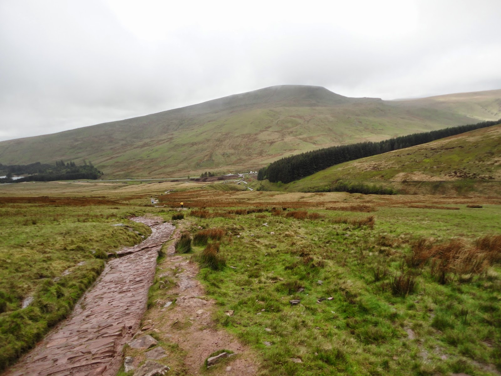
Cribyn and Pen Y Fan

Black Mountains Horseshoe 26/05/2014

A better day weather wise so we decided to do the Black Mountains Horseshoe. We started at Llanbeder, headed up to Crug Hywel then onto Pen Cerrig Calch, Pen Allt Mawr, Mynydd Llysiau, Waun Fach, Pen Y Gadair Fawr, Pen Twyn Mawr then back to Llanbedr!

The hike was 27.6km long with a total ascent of 1206m which took us 7hrs and 46mins.


Walk stats

On Crug Hywel

Looking back at Crug Hywel

On Pen Cerrig Calch

On Pen Allt Mawr

Pen Y Gadair Fawr

Pen Allt Mawr

Saturday, 17 May 2014

Ysgyryd Fawr & Sugar Loaf Mountain

JustGiving - Sponsor me now!

A long one today! Starting from Abergavenny town centre then heading out to Ysgyryd Fawr then onto Sugar Loaf Mountain before heading back to Abergavenny.

A monstrous 23.7km with a 1152m of ascent which took us 6hrs and 14mins.

A little bit about each mountain:

Ysgyryd
Ysgyryd from local folklore is said to be a "holy mountain" maybe because the name translates to the the hill's shape, signifying shivered or been shattered and according to local legend, part of the mountain is said to have been broken off at the moment of the crucifixion of Jesus. There must be something in it as there stands the ruins of  a medieval Roman Catholic church, dedicated to St. Michael, at the summit.

Sugar Loaf
The name itself is due to the shape of the mountain, much like others found around the world! From the summit on a clear day you can see Black Mountains to the north, the Cotswolds to the east, as far as the Brecon Beacons including Pen y Fan and Corn Du to the west and the Bristol Channel to the south.

Stats courtesy of GPS

Threshold of the Church on Ysgyryd


Ysgyryd with Sugar Loaf in the distance

Looking back at Ysgyryd

Sugar Loaf

Sugar Loaf summit


Water wheel at Sugar Loaf Vineyard

Saturday, 10 May 2014

Pen Y Fan - Our foul weather route!

JustGiving - Sponsor me now!
Pen Y Fan seems to be our foul weather route!

The original plan was to do a 24km walk around Sugar Loaf and Ysgyryd Fawr but as you can see below the weather was just not suitable to take on such a long walk! Instead we chose to head up the tourist path from Pont ar Daf with options to do Corn Du, Pen Y Fan, and Cribyn depending on the weather. We evaluated the conditions at Bwlch Duwynt and decided just to head onto Pen Y Fan and head straight back down due to the gale force winds!

The total distance was 6.39km which took us 1hr36mins with a total ascent of 467m.

Weather warnings for the day

Stats courtesy of GPS

Heading to Pen Y Fan

Pen Y Fan

Being buffeted on the top

Heading back to Pont ar Daf

Sunday, 4 May 2014

Llangorse Lake

JustGiving - Sponsor me now!

Today we started at the historic Llangors Lake and explored the surrounding hills/mountains including Allt Y Esgair and Mynydd Llangorse.

The hike was 17.8km long with a total ascent 764m of which took us 4hrs 36mins.

The following provides the words for each placard found on Allt Y Esgair:

Black Mountains:
An Ancient Viewpoint
People have been looking at this view for thousands of years. The ditches and banks surrounding this hill top are the remains of Iron Age hill fort, constructed some 2,500 years ago.

The Iron Age Landscape
The view from here in the Iron Age would have been similar to that we see today. The climate was cool and damp and the uplands of the Black Mountains were covered in heathland and peat bogs. These were used for grazing sheep, cattle and goats. In the lowlands there were many scattered farmsteads, creating a patchwork of small fields. The area covered by woodland was much larger than today. It would have been managed to provide timber as well as charcoal for use in Iron smelting.

Llangorse Lake
The largest natural lake in South Wales, Llangorse has been a major feature of this landscape since the ice retreated, 11,000 years ago. At that time, the outflow north into the Wye valley may have been blocked by ice. the lake would have been much larger, spilling over into the Usk valley at Bwlch.
By the Iron Age, the lake was only slightly larger than that seen today. It would have been very important to the local people, for both food and ritual purposes.

Brecon Beacons:
Ancient Rocks
The rocks forming this hill, and the escarpment of the Brecon Beacons, were made from layers of silt, sand and grit deposited in the lakes and rivers about 400 million years ago. These rivers flowed through the foothills of a mountain range, much higher than the present Beacons.

The Ice Age
Much of today's landscape has been carved out by the action of glaciers. About 20,000 years ago the Brecons were covered by an ice cap. Streams of ice moved down from this ice cap into a large Usk glacier. the ice was studded with rock fragments and acted like giant sand paper, scouring out the impressive "U" shaped valleys we see today. the Allt Y Esgair ridge was sculpted by an ice sheet moving south-east from mid Wales and flowing either side of the ridge to join the Usk glacier.

Forests
About 8,000 years ago the climate was warmer and drier than today. Most of the Brecon Beacons were covered in natural forests containing trees like oak, ash, birch and hazel, and bot the coniferous forests prominent in today's landscape. many wild animals would have roamed these forests, including bears and wolves.


Stats courtesy of GPS

Allt Y Esgair

Black Mountains panorama

"Black Mountains" placard on Alt Y Esgair

"Brecon Beacons" placard on Alt Y Esgair

Brecon Beacons panorama 

Black Mountains

Cairn on the way to Mynydd Llangorse

Mynydd Llangorse summit

Mynydd Llangorse summit

Llangorse Lake

Panorama of the walk today, Llangorse on the left and Esgair on the right